
GEOMETRIC DESIGN
> SCOPE
The scope of work for this project is to improve the existing interchange connecting the SR-60 freeway to Theodore Street in the City of Moreno Valley to accommodate the project purpose and need. Geometric deliverables include the design of all viable alternatives in order to work with the team in recommending an optimal solution. Each design includes the preparation of a Geometric Approval Drawing (GAD) and an Advance Planning Study (APS). Each GAD includes horizontal and vertical alignments, superelevation tables, and typical sections for facilities encompassed in the design proposal for the corresponding alternative. Each APS details the bridge design of Theodore over SR-60 including plan, profile, and cross-section of both the local road and the mainline. Lastly, geometric designers are responsible with working alongside traffic and modeling to prepare a preliminary construction staging plan that is cost-effective and reduces impact to projected users.
> EXISTING SITE CONDITIONS & CONSTRAINTS
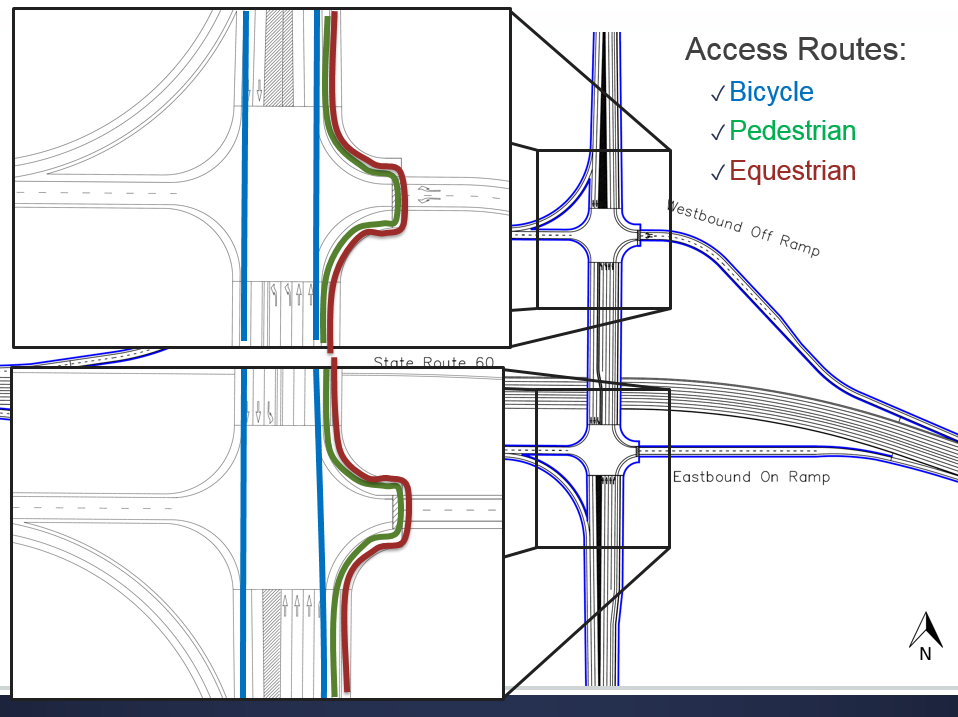
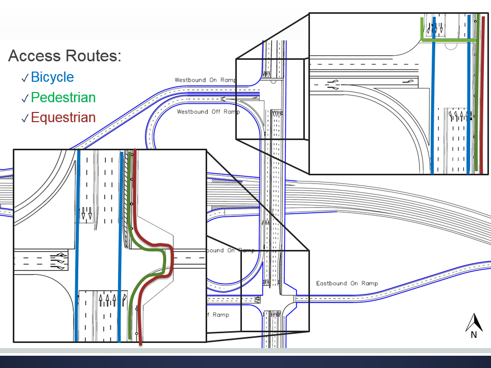
This interchange lies on the eastern city limit of Moreno Valley and connects the freeway to future commercial and residential development. It is spaced one mile east of Redlands Blvd. and less than three quarters of a mile west of Gilman Springs Rd. excluding ramp lengths. The latter poses weaving conflicts between interchange ramps that necessitate auxiliary lanes. Caltrans plans to widen the freeway to three standard lanes in each direction. This expansion may be accomplished inward using the large existing median, but requires some outward expansion where this median narrows east of Theodore. Currently, a commercial warehouse occupies the southwest quadrant and a residential vineyard occupies the northeast quadrant. The undeveloped northwest and southeast quadrants are zoned by the City for residential and industrial development, respectively. Each alternative accommodates motor-vehicle, bicycle, pedestrian, and equestrian traffic with ADA-compliant facilities. Because the current interchange does not accommodate future traffic needs, a new or improved interchange is required.
> ALTERNATIVE DEVELOPMENT
With the purpose, needs, and existing conditions in mind, a team of Geometric designers proceeded to compile a list of alternatives that were deemed viable for further analysis. Initial rejections included standard designs that did not conform to the existing conditions of the site. This included designs intended for interchanges with three-legs, split or non-orthogonal local roads, or frontage roads as well as any designs pertaining only local roads. Subsequently, trumpet-types, split-configurations, and designs with hook or slip ramps were eliminated. Special consideration was given to single and double roundabout alternatives because of their increasing domestic popularity. Preliminary traffic and geometric studies exposed capacity and physical feasibility defects of single and double roundabout interchanges, eliminating the need for further study. The remaining list of viable alternatives, detailed below, required further analysis. Designers worked closely with traffic modelers and sought guidance from engineers employed by Caltrans as well as private consulting firms to optimize each design during the development of each GAD and APS. These deliverables enabled the team to make a more educated decision in selecting a recommended design.
> REJECTED ALTERNATIVES
|
Long Name
|
Short Name
|
Description of Dignifying Features
|
Pros
|
Cons
|
|
Trumpet Interchange
Trumpet Interchange Michigan Urban Diamond Interchange Center Turn Overpass Interchange Echelon Interchange Split Diamond Diamond with U-Turn Frontage Roads Criss-Cross Split Diamond 3-Level or Split Diamond Paperclip 4-Level Stack |
HDM_L-11
HDM_L-12 MUDI CTO GB 10-18 A, B GB 10-18 C GB 10-19 A Volleyball Paperclip |
Theodore Street will cross over SR-60 at a diagonal and the local street will end at the freeway.
Similar to L-11, but the over cross will be perpendicular to SR-60 and Theodore Street will terminate at the freeway. Uses directional crossovers beyond main intersection to hand left turns. All left turn traffic are separated. One approach is grade separated. Two, separated crossroad intersections. Frontage roads parallel to cross street. Four intersections, artificial split. Allows access to parallel local road. |
Good for use when a crossroads terminates at a freeway.
Good for use when a crossroads terminates at a freeway. Good for accessing in a management point-of-view. Good at separating left and right turn movements. Higher capacity than at-grade intersections. Reduces left-turn delay. Allows immediate U-turn; useful for heavy-traffic cross streets. Eliminates weaving. More capacity than diamond; less lateral space than clover. No weaving; single 4-way intersection. Fully directional. |
Not applicable for Theodore Street, three-legs only.
Not applicable for Theodore Street, three-legs only. Not viable for semis; not enough space with additional two U-turn intersections along SR-60; additional structure adds cost. Requires merging/deceleration lane; street-street, not freeway-street. U-turns not available at interchange; street-street, not freeway-street. Traffic exiting the freeway cannot reenter immediately in the same direction. Left turn to freeway required; intricate frontage streets. Requires intricate frontage streets and large acceleration. Additional structure adds cost; artificially split local road adds length, exacer-bating weaving issue. Only for parallel roads. Freeway-freeway not freeway-street. |
> ALTERNATIVE SELECTION PROPERTIES
A preliminary alternative selection process was conducted in order to determine viable alternatives. The alternatives would be viable if they meet the general purpose and needs of this interchange improvement project. When determining these alternatives, special consideration was given to the geometric constraints of the site, right of way acquisition, intersection spacing, and interchange spacing to the adjacent interchanges. With two existing developments in the northeast and southwest corners of the project site, geometric improvements were considered to minimize the impact to the areas and avoid major right of way acquisitions. Due to the nearby Gilman Springs interchange, that is approximately 0.6 miles to the east of Theodore Street, special considerations were given to the designs. Through engineering judgment, the alternatives that were considered include:
- Hybrid Diamond Interchange (HDI)
- Partial Cloverleaf Interchange (ParClo)
- Diverging Diamond Interchange (DDI)
- Single Point Urban Interchange (SPUI)
- Continuous Flow Interchange (CFI)
> DESCRIPTION OF ALTERNATIVES
Alternative 0. No-Build
The No-Build alternative consists of keeping the current interchange configuration with no improvements. This alternative is used to compare the other four alternatives with the projected 2040 traffic volumes.
The No Build alternative means that there will be no construction for improvement, which is a large advantage because there will be no construction cost. However, with no improvement, the current interchange will not be able to accommodate for future traffic needs.
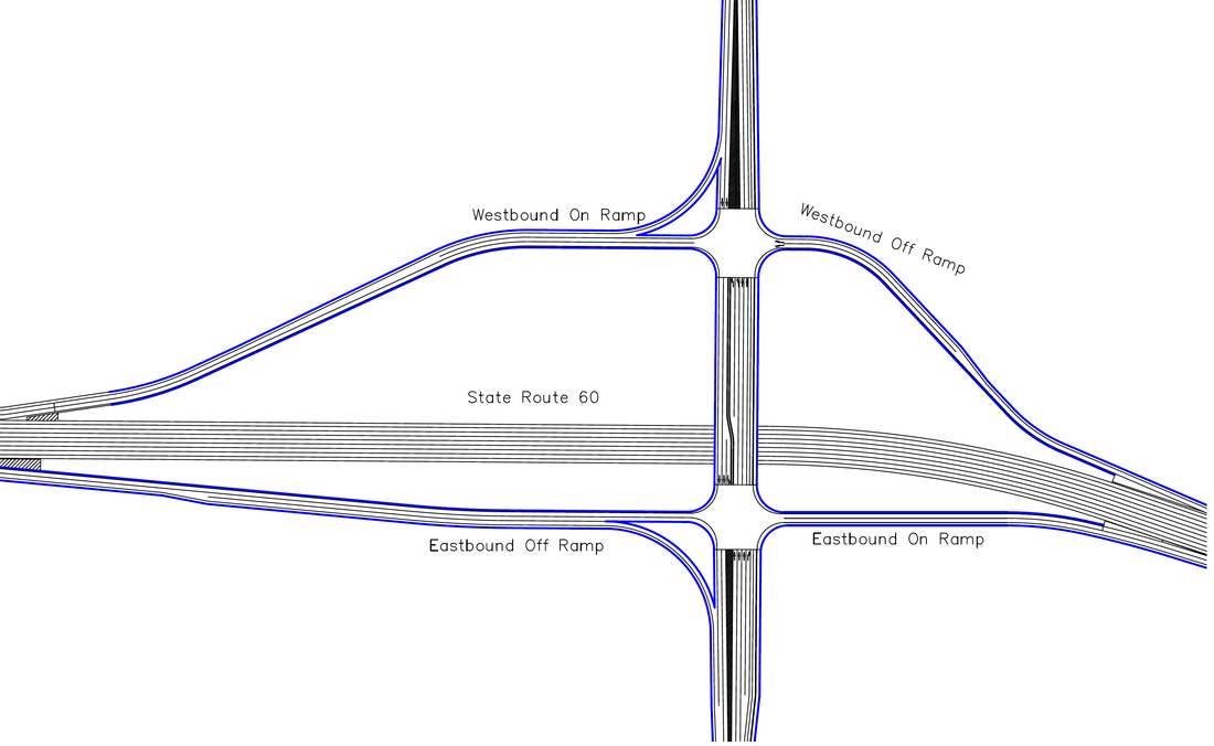
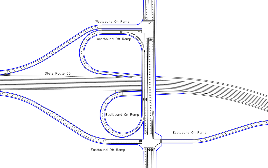
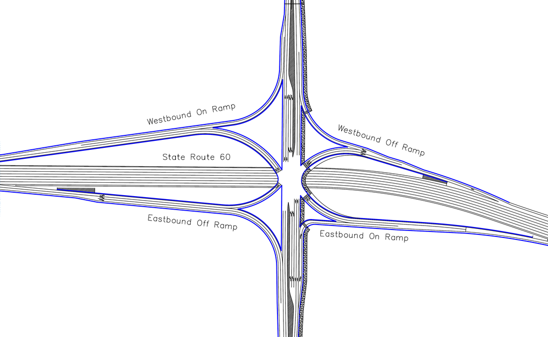
The current interchange consists of hook ramps that terminate onto Theodore Street. The tight turning radii are not suitable for trucks. The sidewalk on Theodore Street is only accessible on the left side of the street facing north and that does not have easy accessibility to pedestrians, bikes, and equestrians. Below is a figure of the current interchange along with the LOS table with future traffic volumes.
The No-Build alternative consists of keeping the current interchange configuration with no improvements. This alternative is used to compare the other four alternatives with the projected 2040 traffic volumes.
The No Build alternative means that there will be no construction for improvement, which is a large advantage because there will be no construction cost. However, with no improvement, the current interchange will not be able to accommodate for future traffic needs.
The current interchange consists of hook ramps that terminate onto Theodore Street. The tight turning radii are not suitable for trucks. The sidewalk on Theodore Street is only accessible on the left side of the street facing north and that does not have easy accessibility to pedestrians, bikes, and equestrians. Below is a figure of the current interchange along with the LOS table with future traffic volumes.
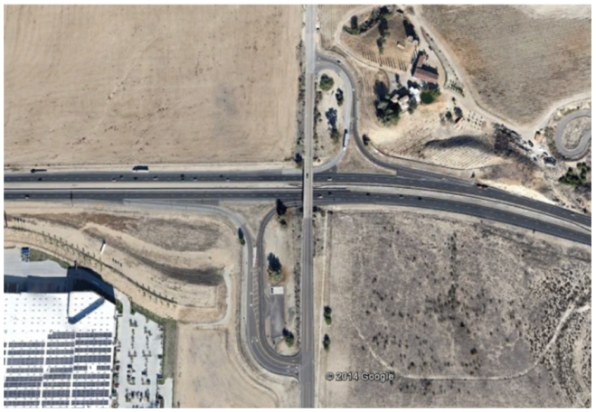
No-Build Alternative (Existing)
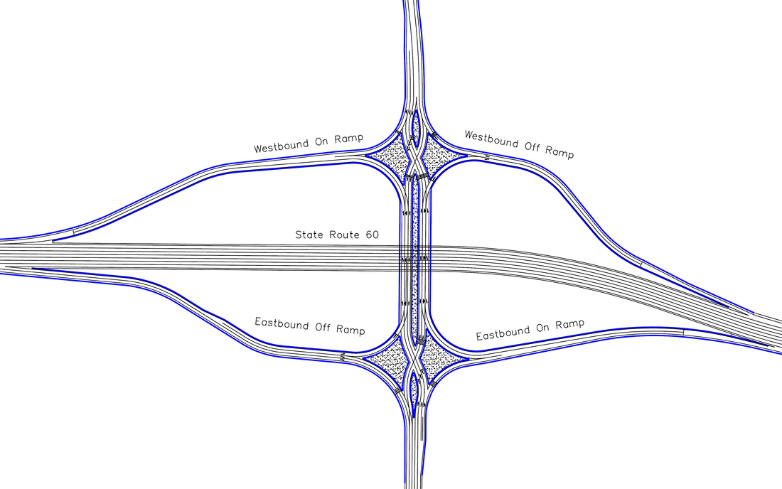
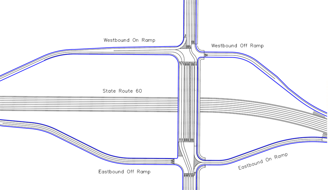
The Hybrid diamond interchange, shown in figure 7, is an interchange design that is commonly found in California. The simple characteristic meets driver expectation. This interchange is a combination of a tight diamond on the southern section and a spread diamond on the northern section, which offers good intersection spacing and higher capacity on Theodore Street. The spread diamond ramps allow for future expansion that may include a loop ramp inside the diagonal ramps.
Alternative 1. Hybrid Diamond Interchange (HDI)
These traditional diamond interchanges are common to Southern California, eliminating learning curves for the user. The ramps are widely spaced, which will allow more storage length on Theodore St. Furthermore, spread-diamond sections will accommodate future expansion that may include a loop ramp inside the diagonal ramps. Although this ramp is very simple and requires only moderate right-of-way acquisition, it will not eliminate the weaving conflict between Theodore St. and the nearby Gilman Springs Rd. trumpet interchange. Another drawback is that the close spacing of ramp intersections on Theodore may not accommodate storage requirements for left-turning traffic from northbound Theodore to the westbound SR-60.
Hybrid Diamond Interchange - Plan View
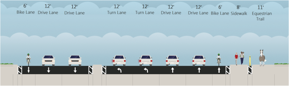
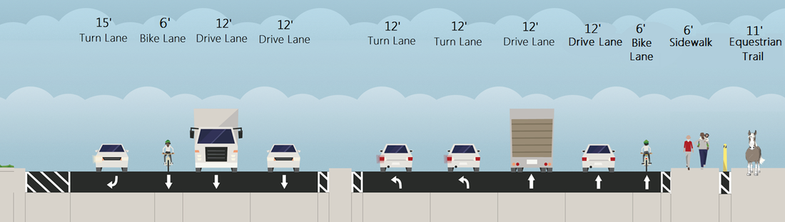
Hybrid Diamond Interchange - Cross-Section Over Bridge
Alternative 2. Partial Cloverleaf Interchange (ParClo)
The partial cloverleaf alternative combines loop and diagonal ramps with which many local users are familiar. Ramp configuration is chosen to reduce social and environmental impact, accommodate heavy turning demands, minimize weaving conflict, and simplify ease of use. By using a loop westbound off-ramp, this alternative avoids impact to the existing ranch property, maximizes weaving length from Gilman Springs, and reduces conflicts with non-motorized traffic. Drawbacks include relatively large right-of-way impact due to loop ramps and long signal phases for left turns that cross oncoming traffic on Theodore to enter the westbound on-ramp.
The partial cloverleaf alternative combines loop and diagonal ramps with which many local users are familiar. Ramp configuration is chosen to reduce social and environmental impact, accommodate heavy turning demands, minimize weaving conflict, and simplify ease of use. By using a loop westbound off-ramp, this alternative avoids impact to the existing ranch property, maximizes weaving length from Gilman Springs, and reduces conflicts with non-motorized traffic. Drawbacks include relatively large right-of-way impact due to loop ramps and long signal phases for left turns that cross oncoming traffic on Theodore to enter the westbound on-ramp.
Partial Cloverleaf Interchange - Plan View
Partial Cloverleaf Interchange - Cross-Section Over Bridge
Alternative 3. Diverging Diamond Interchange (DDI)
A diverging diamond interchange (DDI) is a variation from the typical diamond interchange. It differs from other diamond interchanges by allowing through traffic in both directions to temporarily crossover to the left side of the road between the intersections. The directional ramps to the local road allow free left and right turns which lower the amount of conflict points compared to a typical diamond interchange. This lowers the signal phase count to two which leads to higher capacity and lower delay.
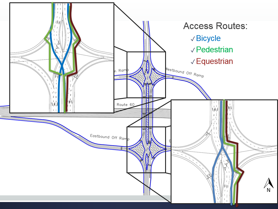
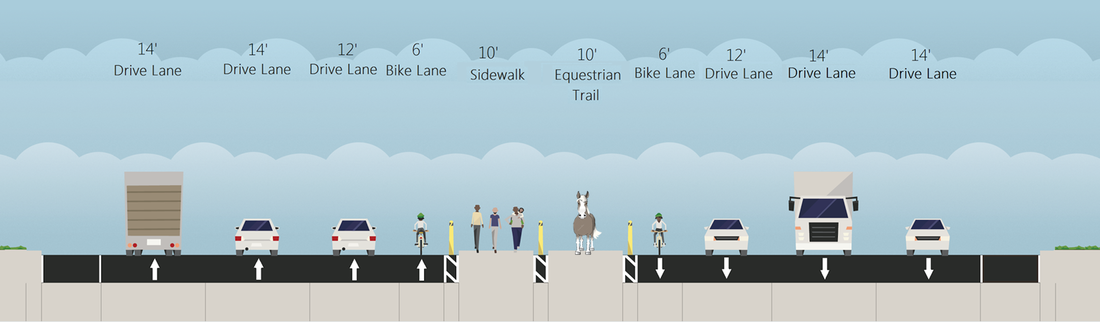
Non-motorized traffic is accommodated on this interchange. Pedestrians and equestrians use a system of islands and median walkways, to navigate the interchange. Bicyclists can follow motorized traffic on the right-hand shoulder or use the sidewalks and medians that pedestrians and equestrians use to navigate the interchange.
Drivers exiting the freeway can make U-Turns to the reverse direction of freeway travel. However, exiting vehicles are not provided with immediate points of re-entry in the same direction of freeway travel. The DDI’s lower design speed and crossover sections serve as a traffic-calming measures, reducing environmental impact but impeding through-traffic capacity of Theodore. This type of interchange is uncommon in the area which presents a learning curve to drivers and pedestrians. Finally, its tight geometry is more difficult to modify to accommodate configuration changes when compared to typical diamond interchanges.
A diverging diamond interchange (DDI) is a variation from the typical diamond interchange. It differs from other diamond interchanges by allowing through traffic in both directions to temporarily crossover to the left side of the road between the intersections. The directional ramps to the local road allow free left and right turns which lower the amount of conflict points compared to a typical diamond interchange. This lowers the signal phase count to two which leads to higher capacity and lower delay.
Non-motorized traffic is accommodated on this interchange. Pedestrians and equestrians use a system of islands and median walkways, to navigate the interchange. Bicyclists can follow motorized traffic on the right-hand shoulder or use the sidewalks and medians that pedestrians and equestrians use to navigate the interchange.
Drivers exiting the freeway can make U-Turns to the reverse direction of freeway travel. However, exiting vehicles are not provided with immediate points of re-entry in the same direction of freeway travel. The DDI’s lower design speed and crossover sections serve as a traffic-calming measures, reducing environmental impact but impeding through-traffic capacity of Theodore. This type of interchange is uncommon in the area which presents a learning curve to drivers and pedestrians. Finally, its tight geometry is more difficult to modify to accommodate configuration changes when compared to typical diamond interchanges.
Diverging Diamond Interchange - Plan View
Diverging Diamond Interchange - Cross-Section Over Bridge
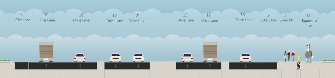
Alternative 4. Single Point Urban Interchange (SPUI)
The single point urban interchange (SPUI), also known as a single point diamond interchange (SPDI), is similar to a traditional tight diamond in ramp configuration, but differs by merging the two intersections with the local road into one. In turn, this allows opposing left turns exiting the freeway to proceed simultaneously, reducing travel time on the bridge. Because these turns are wide, they also better accommodate heavy good vehicle (truck) movement. In addition, all right turn movements flow freely with directional ramp sections. The SPUI thereby capacitates high traffic volume efficiently through a compact right-of-way on Theodore.
The major disadvantage of the SPUI is the increased cost due to the need for a wider and longer bridge. Because local users are not familiar with this design, the uncommonly large intersection may lead to confusion. Also, the additional time needed for cyclists to cross the large intersection may reduce its capacity. Similarly, pedestrian traffic may take up to four cycles to completely traverse the bridge.
Single Point Urban Interchange - Plan View

Single Point Urban Interchange - Cross-Section Over Bridge
Alternative 5. Continuous Flow Interchange (CFI)
The main feature of the continuous flow intersection is the relocation of the left-turn movement on an approach to the other side of the opposing roadway, which consequently eliminates the left-turn phase for this approach at the main intersection.
Continuous flow intersections can help maximize capacity and decrease delay by allowing smoother traffic flow through the intersection. This design alters the intersection to separate left-turns and through traffic. Multiple traffic streams (turning and through) can proceed at the same time, reducing congestion when compared to traditional intersections.
Continuous Flow Interchange - Plan View
Continuous Flow Interchange - Cross-Section Over Bridge
> APS
An Advance Planning Study is required by Caltrans for the Project Study Report (PSR) to document the scope of structural work on a project. This consists of one plan sheet showing basic bridge structure layout details. Because each alternative is unique, each had an APS as shown below that includes plan, profile, and cross-section of the bridge along Theodore that crosses the SR-60 freeway.
> ATTACHMENTS
Provided below is a link to the Geometric Approval Drawings (GADs) for each alternative. GADs show information for both horizontal and vertical designs for each intersection.
|
| ||||||||||||||||||||
