
ENVIRONMENTAL
> PURPOSE
The SR-60 Interchange Improvement Project at Theodore Street proposes several potential environmental impacts and risks at the project study boundary. The need for an environmental assessment resulted in the production of the Preliminary Environmental Analysis Report (PEAR), a Caltrans directive that documents issues and assumptions to be addressed by the National Environmental Protection Agency (NEPA) and California Environmental Quality Act (CEQA). The PEAR will determine the anticipated environmental approval for the project at the SR-60 and Theodore Street Interchange.
> PRELIMINARY ENVIRONMENTAL ANALYSIS REPORT (PEAR)
The PEAR briefly introduces the SR-60 Improvement Project and restates the purpose and needs. It explains each proposed alternative and assesses any initial environmental doubt. Special environmental constraints that may require future environmental processes are explained in the PEAR. Anticipated environmental commitments by impacted resources are summarized briefly. The permits and approvals necessary for the project are listed. Any important consideration that might affect the level of effort and resources are assumed. The PEAR continues with a summarized study of common environmental issues. These issues are environmental risks that usually affect a project's delivery. An anticipated environmental approval is determined at the conclusion of the report to explain what documentation will be required in the next phase of the environmental analysis.
> ANTICIPATED ENVIRONMENTAL COMMIMENTS
Anticipated environmental commitments will be thoroughly documented within the Environmental Document (ED) and an Initial Study/Environmental Assessment (IS/EA) will be performed in order to provide proper mitigation. The result of the IS/EA will be a Negative Declaration/Finding of No Significant Impact or FONSI. Compliance with the California Environmental Quality Act (CEWA) and National Environmental Policy Act (NEPA) will be ensured through the completion of this project. Environmental commitments will be necessary for the following:
- Land Use: Preliminary land use studies indicate there may be right-of-way impacts. Study involving land use compatibility required.
- Community Impacts: Displacement of community values may occur. Community Impact Assessment (CIA) needed.
- Visual/Aesthetics: Introduction of more lanes may affect designated scenic routes and City of Moreno Valley existing scenic resources. Visual Impact Assessment required.
- Cultural Resources: Properties considered historic located on Anco Ranch. Historic Properties Survey Report (HPSR) and Historic Resource Evaluation Report (HRER) will be required to confirm status of these properties.
- Hydrology and Floodplain: On-site hydrologic study of existing and proposed conditions must be prepared to assess increase in stormwater runoff as a result of increased impervious surfaces. Off-site hydrology analysis will need to be completed as well.
- Water Quality and Storm Water Runoff: Commitments necessary during construction in accordance with the Clean Water Act (CWA) through the use of Best Management Practices (BMPs) and the preparation of a Stormwater Pollution Prevention Plan (SWPPP).
- Geology, Soils, Seismic and Topography: Nearby San Jacinto Fault required geology study to determine precise location. Preliminary Geotechnical Study needed as well to analyze soil conditions and existing topography.
- Paleontology: Paleontological Identification Report (PIR) necessary.
- Hazardous Waste/Materials: Potential hazardous waste/materials will be analyzed and discussed.
- Air Quality: Traffic simulations and Air Quality Analysis will be performed.
- Noise and Vibration: Abatement is expected. Vibration Study will be required.
- Biological Environment: National Environmental Study must be prepared to ensure endangered animals such as the Burrowing Owl is not harmed in the construction of the proposed project.
> PEAR TECHNICAL SUMMARIES
 Anco Ranch
8.1: Land Use
The purpose of the Theodore Street interchange project is to improve traffic flow and non-motorized mobility to accommodate existing and future build outs. The proposed build alternatives will modify the interchange without relocating existing developments and include the addition of an equestrian trail. These developments include Sketchers Factory and Anco Ranch located in the southwestern and northeastern quadrants, respectively. Land use goals outlined in the City of Moreno Valley General Plan were taken into design consideration. The figure below depicts the specified land uses within the project study boundary.
Land use conflicts may arise for the Partial Cloverleaf Interchange (ParClo) and the Spread Diamond Hybrid Interchange build alternatives. For both, right-of-way will be largely impacted due to the ramp design requiring purchase of private lands. However, the Single Point Urban Interchange (SPUI) and Diverging Diamond Interchange (DDI) build alternatives are not expected to impact land use. The Environmental Document (ED) will cover more information regarding land use compatibility. No separate technical report is required.
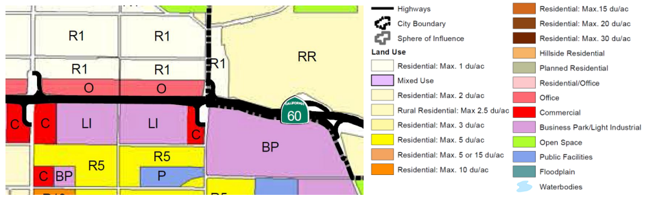
Land Use Map (City of Moreno Valley General Plan 2006)
Regional Population, Housing, and Employment Forecasts (WLC Draft EIR 2013)
|
8.2: Growth
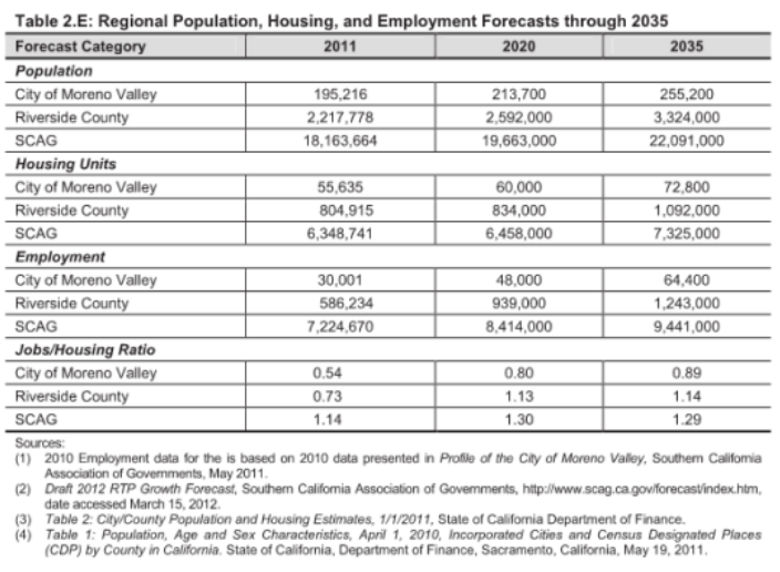
Within the City, substantial growth is expected to occur with the introduction of the World Logistics Center (WLC). The center is expected to drastically increase truck traffic within the project limits. According to the Moreno Valley General Plan, truck traffic will be concentrated onto Theodore Street for the future area build out. The figure to the left shows the projected employment forecasts for the City of Moreno Valley through 2035 where employment is expected to double. The proposed project is designed to accommodate these future needs in order to relieve nearby congestion and to improve traffic flow in accordance with the Riverside County Integrated Project (RCIP). Traffic operations will be improved to meet the expected region growth and to enhance the non-motorized transportation safety, which includes pedestrians, bicyclists, and equestrians. The project itself is not expected to lead to growth beyond what has been planned. |
8.3: Farmlands/Timberlands
Farmlands of Local Importance exist within all four quadrants of the design boundary as shown in the figure below. The ParClo and Tight/Spread Diamond Hybrid build alternatives may affect the existing farmland due to ROW conflicts. However, referencing the City of Moreno Valley Land Use Map shown in the 8.1 Land Use section, plans for future development exist.
Farmlands of Local Importance exist within all four quadrants of the design boundary as shown in the figure below. The ParClo and Tight/Spread Diamond Hybrid build alternatives may affect the existing farmland due to ROW conflicts. However, referencing the City of Moreno Valley Land Use Map shown in the 8.1 Land Use section, plans for future development exist.

Important Farmlands (City of Moreno Valley General Plan 2006)
8.4: Community Impacts
The City is dominated by residential land use. The western portion has a relatively urban atmosphere whereas the east is primarily rural. Major impacts to the community is not expected to occur as a direct result from any of the design alternatives. A Community Impact Assessment (CIA) will be performed to confirm this assumption and its findings will be incorporated in the ED. The analysis will address impacts related to the socioeconomic characteristics within the established project area and its surroundings. Relocation of existing developments or changes in future land uses as stated in the City General Plan is not anticipated and environmental justice communities will not be affected.
Special consideration will be made in ensuring the project does not result in a change of the community culture. The different interchange proposals include the addition of an equestrian trail to accommodate Moreno Valley's plan for a system of horse trails within the City. The inclusion of the trail is meant to incorporate the rural character of the eastern portion of the City and serve the needs of its residents. In addition, sidewalks and bikeways will be improved to facilitate an improved transportation network. Each build alternative will be designed to ensure the improvement is consistent with the City General Plan in retaining the agricultural aspect of the area as well as providing a buffer between the future land uses.
Temporary impacts such as lane closures and detours may arise during construction and as a result impact local residents with increased commute times. Traffic studies will be performed in order properly to mitigate these issues. Relocation of existing utilities running along the overpass will also be required. This includes an Edison line on the west side of Theodore and a MWD distribution water line on the southwest section of Theodore.
8.5: Visual/Aesthetics
A Visual Impact Assessment (VIA) will be performed to study the potential effects of each of the build alternatives. The SR-60 crossing Theodore Street and the interchange itself are designated as scenic routes as shown in the figure below. The highway provides views of the major scenic resources within Moreno Valley, which includes the relatively flat valley to the west, “Badlands” hills to the east, and Russell Mountains to the south. Together, these areas provide the City with outstanding views. The “Badlands” forms the eastern boundary of the project area and provides a wide range of hills that act as a visual backdrop to the valley.
Although the project is an improvement of the existing interchange, each of the build alternatives would introduce a new ramp configuration, bridge widening, and higher profile. Special attention to the design and landscaping of the interchange will be made to protect and preserve the views of the “Badlands” and surrounding areas. Each of the alternatives is designed to minimize its visual impact on the community and instead enhance views from its roadways. Necessary aesthetic treatment and sustainable landscape design will be implemented. Temporary visual impacts will also arise during construction, but are not expected to cause permanent impacts to the City’s scenic resources.

Major Scenic Resources Important Farmlands (City of Moreno Valley General Plan 2006)
 Listed Historic Resource Inventory Structures in Moreno Valley (City of Moreno Valley General Plan 2006)
8.6: Cultural Resources
Within the project study boundary are three structures built in 1915 located inside the Anco Ranch property. The figure below depicts the general location of these structures. According to the figure to the right, the structures (12400 Theodore Street) are listed as part of the Moreno Valley Historic Resource Structural Inventory. Presently, the structures are no longer considered historic due to changes in their architectural integrity. Retrofitting the structures within Anco Ranch is recommended to reduce the potential impacts of the proposed project. The City General Plan states there are no sites within the City listed as state landmarks, however a Historic Properties Survey Report (HPSR) and Historic Resource Evaluation Report (HRER) will be prepared to confirm this statement. The project is expected to improve traffic flow to the nearby Badlands Landfill.
The Theodore overpass, which was built in 1962, is also not considered historic. Though the bridge is over fifty years of age, the bridge was recently struck on January 30, 2015 and is scheduled for demolition and rebuild. Since architectural and structural changes will be made to the overpass, the bridge will no longer be considered as potentially historic. Therefore, a No Historic Properties Affected or No Adverse Effect with Standard Conditions will be documented. In addition, no archeological sensitive areas exist with the project area as confirmed in the figure below. No known human remains were also identified in the Study of Historical and Archeological Resources as stated in City of Moreno Valley Environmental Impact Report (EIR).

Locations of Listed Historic Resource Inventory Structures (City of Moreno Valley General Plan 2006)
8.7: Hydrology and Floodplain
The improvement is expected to alter the local drainage of the project area. As such, a detailed on-site hydrologic analysis will need to be performed and be included within the ED. Each alternative involves expanding the bridge to a width more than double its current size, thereby increasing the amount of impervious surfaces. Overall, however, the project will not significantly affect the regional drainage area. The stormwater runoff will increase as a result of widening the bridge, though to a volume that is sustainable by existing drainage facilities. Some of these facilities include a box culvert underneath SR-60, culverts east and west of the interchange crossing SR-60, and a roadway channel running along the southern portion of the SR-60. Shown in the figure below to the left, the project site is located in between a natural drainage divide. East of the divide the water flows to the San Jacinto River while west of the divide, the water flows to the Santa Ana River. In order to minimize the impacts on nearby drainage facilities, the runoff will be effectively diverted east and west to preserve the natural drainage courses.
As for flood risks, the project site does not fall within the City of Moreno Valley’s 100-year floodplains as indicated in the figure below to the right. However, the volume of additional runoff may serve as a potential flooding hazard during major rainstorms. An off-site drainage study will be completed to further analyze the overall hydrologic impact of the proposed project to surrounding areas.
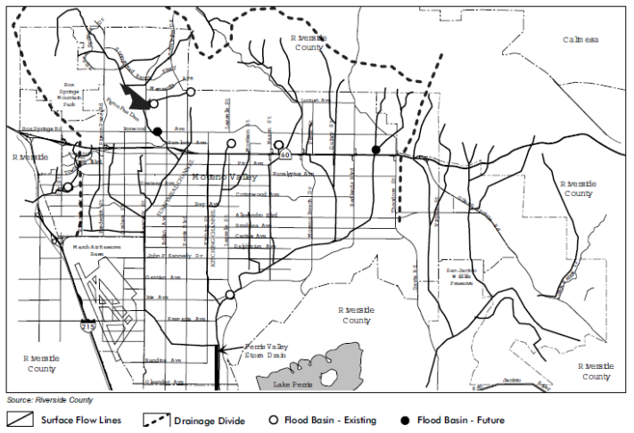
Storm Water Flows and Major Drainage Facilities (Moreno Valley Final Program EIR 2006)
|
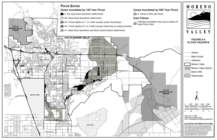
Flood Hazards Facilities (City of Moreno Valley General Plan 2006)
|
8.8: Water Quality and Storm Water Runoff
The amount of stormwater runoff is expected to increase as a result of the widening of the bridge. The increase in impervious surface may potentially degrade water quality due to the additional runoff. In addition, the increase in impervious surfaces will increase the amount of pollution to waterways connected to existing drainage facilities. Blue line streams designated as Waters of the United States may be affected as a result of the project. The stream can be located within the figure above to the left, east of the project site between Gilman Springs and Theodore. Permitting will be required in compliance with Section 404 Section 401 of the Clean Water Act (CWA) in order to regulate possible pollutants that may be discharged into these waters during the construction of the project.
The Santa Ana Regional Water Quality Control Board establishes water quality standards for all the ground and surface waters within the region. A Stormwater Pollution Prevention Plan (SWPPP) will be prepared in accordance with these standards. Additionally, implementation of Best Management Practices (BMPs) is recommended to minimize stormwater runoff impacts to water quality in accordance with the National Pollutant Discharge Elimination Stormwater (NPDES) permits. Design of the interchange will incorporate the use of BMPs to retain and treat water before being discharged into the Waters of the United States. Not only will the BMPs aide in treating water, but they will assist in minimizing the impact of the project to existing drainage facilities and local hydrology. In order to minimize maintenance costs, BMPs will be self-maintained through the use of native grasses and be placed in open areas. A Water Quality Assessment Report will be prepared and included within the ED.
|
8.9: Geology, Soils, and Topography
Special consideration is necessary for the “active” San Jacinto Fault which is in close proximity to the City of Moreno Valley. The fault runs along the eastern city limits directly on top of the northeastern portion of the project site as shown in the figure to the right. As depicted in the figure, the fault cuts directly through the northeastern portion of the project site. The fault is considered the most active fault in California and an Alquist-Priolo Special Fault Zone has been established. The improvement of the existing interchange will account for the possibility of ground rupture and the structural design of the bridge will comply with current codes and regulations for seismic activity. A geologic study is necessary to determine the precise location and necessary setbacks from the fault. The project would have little to no effect on the local topography due to the rise in ramps for the bridge approaches and would have no effect on local soils. In regard to the soils and topography of the site, a Preliminary Geotechnical Study will be prepared in order to determine the site’s soil characteristics and establish criteria for cut and fill slopes. |

Seismic Hazards (Moreno Valley Final Program EIR 2006)
|
 Paleontologic Resource Sensitive Areas (Moreno Valley Final Program EIR 2006)
8.10: Paleontology
The future build site may consists of sedimentary rock that has the potential to contain paleontological fossils. The northeast quadrant has a high potential while the remaining site is categorized as low potential as shown in the figure to the left. The two primary sedimentary rock-units within the area are referred to as the Mt. Eden Formation and the San Timoteo Formation. Sediments within these formations contain a variety of fossilized fauna including horse, peccary, antelope, camel, deer, mastodon, sloth, tortoise, sabertooth cat, bear, and rabbit. In addition, these areas are known to produce diverse fossil remains from as old as 5 million years to 1.3 million years or less. Any developments within the “Badlands” hillside could result in grading or excavation in areas with potential or known paleontological resources. If such impacts were to occur, the City will require measures to mitigate the impacts. In this case, the City would declare the project a significant impact. A Paleontological Identification Report (PIR) will need to be prepared to document the potential for presence of paleontological resources in the project area.
The future build site may consists of sedimentary rock that has the potential to contain paleontological fossils. The northeast quadrant has a high potential while the remaining site is categorized as low potential as shown in the figure to the left. The two primary sedimentary rock-units within the area are referred to as the Mt. Eden Formation and the San Timoteo Formation. Sediments within these formations contain a variety of fossilized fauna including horse, peccary, antelope, camel, deer, mastodon, sloth, tortoise, sabertooth cat, bear, and rabbit. In addition, these areas are known to produce diverse fossil remains from as old as 5 million years to 1.3 million years or less. Any developments within the “Badlands” hillside could result in grading or excavation in areas with potential or known paleontological resources. If such impacts were to occur, the City will require measures to mitigate the impacts. In this case, the City would declare the project a significant impact. A Paleontological Identification Report (PIR) will need to be prepared to document the potential for presence of paleontological resources in the project area.
8.11: Hazardous Waste/Materials
An Initial Site Assessment (ISA) will be conducted to determine if there are any hazardous materials present within the project study area. Riverside County Waste Management Department’s (RCWMD) Badlands Landfill, located near Theodore Street about 1.5 miles north of SR-60, may serve as a possible source of soil and/or groundwater contamination. The landfill is found on the Leaking Underground Storage Tank (LUST) database and is classified as a land disposal site. The cleanup status at the site is currently “open – operating”. This description defines the landfill as a land disposal site that is accepting waste and have been issued waste discharge requirements by the appropriate Regional Water Board, which in this case is the Riverside Water Quality Control Board (RWQCB). A review of the general history of the landfill indicates the site suffers from drainage and erosion control issues and has been cited with unauthorized discharge of leachate. Appropriate measures to mitigate the possibility of contaminated soils and/or groundwater contamination will be prepared.
The removal of the existing bridge, which was built in the 1960s, should be carefully monitored for possible asbestos and lead contamination. In addition, the increased vehicle capacity may lead to added asbestos contamination from the continual breaking of cars and trucks. Pesticide surveys will also be performed as the study area has a history of past and present farming operations. The proposed project will need to comply with current state and federal regulations concerning hazardous materials. Detailed analyses and discussion on hazardous wastes/materials will be presented within the ED to avoid or minimize possible impacts.
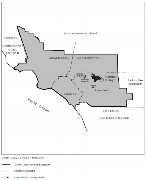
8.12: Air Quality
The project is located within the South Coast Air Basin (Basin) and is under the jurisdiction of the South Coast Air Quality Management District (SCAQMD). The figure below depicts the location of the City within the Basin. The Basin is known to have some of the worst air quality problems in the nation and is known to retain pollutants for substantial periods of time. Due to this issue, the Basin continues to fail to meet state and federal standards and is currently a “non-attainment” area for ozone, nitrogen dioxide, carbon monoxide, and fine particulate matter.
The long term goal of this project is to reduce future congestion due to expected growth in the area, therefore, reducing the negative impact on air quality. However, the project is expected to have a minor short term impact during the construction phase. The project will comply with regulations established by the SCAQMD and an Air Quality Analysis as well as an Air Quality Conformity Analysis will be performed. Traffic assessments are being performed to analyze the effects of the increased truck traffic expected from the World Logistics Center. These assessments will study the amount of COs saved in connection with general traffic delay for each alternative in order to reduce potential cancer risks that may result from the truck traffic coming to and from WLC.
8.13: Noise and Vibration
The Theodore Street interchange improvement is expected to increase noise and vibration during and post-construction. According to Title 23: Highways within the Code of Federal Regulations (CFR) Part 772-Procedures for Abatement of Highway Traffic Noise and Construction Noise, the proposed project is classified as Type I. The Federal Highway Administration (FHWA) defines Type I projects as projects that involve construction of a highway on a new location or the physical alteration of an existing highway that significantly changes either the horizontal or vertical alignment or increases the number of through-traffic lanes. For such projects, noise regulations requires noise analyses to be performed.
Preliminary investigation indicates increased noise levels will result from the construction and use of the future interchange. As such, noise abatement will have to be considered in the design of the Thproject to reduce noise impacts for the existing Anco Ranch and future residential developments. The noise analysis will focus on noise levels when traffic movement is fast (typically from 9AM-3PM), the effects of increased truck usage on the interchange, and noise sensitivity of the project study area. A vibration study will be performed to analyze the potential of increased vibration from expected truck growth. Both the noise analysis and vibration study will be included within the ED.
8.14: Energy and Climate Change
The proposed project is not expected to impact energy resources and thus, will not require a technical energy report. Air quality is expected to improve from the smother flow of traffic that this project aims to produce. Increased traffic flow created by this project will create fewer delays and less greenhouse gas emissions. A more detailed analysis of greenhouse gas emissions is done within the Air Quality portion of the PEAR.
The proposed project is not expected to impact energy resources and thus, will not require a technical energy report. Air quality is expected to improve from the smother flow of traffic that this project aims to produce. Increased traffic flow created by this project will create fewer delays and less greenhouse gas emissions. A more detailed analysis of greenhouse gas emissions is done within the Air Quality portion of the PEAR.
8.15: Biological Environment
The project is contained in two biological geographic sections. The area south of SR-60 is considered a part of the central section, while the area to the north is a part of the Norton Younglove section.
The project area is considered to be in a field/croplands environment. These areas generally do not contain substantial native vegetation. The main concern is for the Riversidean Sage Shrub, which is decreasing in numbers throughout California. An on-site evaluation is required as this plant may be located within the build area.
In addition, there are many different species of reptiles, birds, and small land mammals that may be encountered in the project area. Two of the most notable are Stephens' Kangaroo Rat and San Bernardino Kangaroo Rat. Both of these animals are considered to be endangered by the federal government. Any development of land must comply with the long-term HCP for the Stephens' Kangaroo Rat. Another animal that may be found within the project boundary is the Burrowing Owl. The Burrowing Owl is a part of the Specific Habitats Endangered Species list. Therefore, an additional survey will be required to assess potential impacts to its habitats as required by the Western Riverside County Multiple Species Conservation Plan (MSHCP). A National Environmental Study will be prepared in order to assess the potential impacts to the biological environment prior to construction.
8.16: Cumulative Impacts
The improvement of the existing Theodore Street interchange and the associated frontage street intersections are not expected to result in negative cumulative impacts. In accordance with the City General Plan land use map shown in 8.1 Land Use section, the proposed project will improve vehicle capacity and traffic operations for future developments. Not included within the General Plan is the construction of the World Logistics Center (WLC). The WLC is a planned development and is estimated to drastically increase truck traffic in the area. Each of the alternatives are designed to mitigate the potential traffic issues that may arise as a result of these future developments.
The impacts of the intersection improvement, combined with the construction of the planned developments, may be considerable to the local community. A detailed cumulative analysis is needed to further evaluate its effects to the area and its potential to lead to negative environmental impacts. The full analysis will be documented within the ED. The project is, however, expected to positively improve traffic operations.
8.17: Context Sensitive Solutions
Context Sensitive Solutions (CSS) are used by Caltrans as an approach to plan, design, construct, maintain, and operate its transportation system. The use of CSS balances community, aesthetic, historic, and environmental values with transportation safety, maintenance, and performance goals. City values will be integrated into the design to incorporate and provide opportunities for public involvement. Additionally, traffic forecasts and safety considerations will be used to control the design of the project.
Context Sensitive Solutions (CSS) are used by Caltrans as an approach to plan, design, construct, maintain, and operate its transportation system. The use of CSS balances community, aesthetic, historic, and environmental values with transportation safety, maintenance, and performance goals. City values will be integrated into the design to incorporate and provide opportunities for public involvement. Additionally, traffic forecasts and safety considerations will be used to control the design of the project.
> ATTACHMENTS
Provided below is a link to the Preliminary Environmental Analysis Report (PEAR) for this project.
| SR-60 Theodore St Interchange Improvement PEAR.pdf |
